
Thank you for supporting this site ❤️
Make a donation
Make a donation
Kampos topographic map
Click on the map to display elevation.
Thank you for supporting this site ❤️
Make a donation
Make a donation
About this map
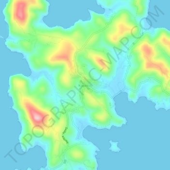
Name: Kampos topographic map, elevation, terrain.
Average elevation: 45 m
Minimum elevation: -1 m
Maximum elevation: 206 m
Thank you for supporting this site ❤️
Make a donation
Make a donation
Other topographic maps
Click on a map to view its topography, its elevation and its terrain.
Kalymnos
Greece > Aegean > Kalymnos Regional Unit
Kalymnos is mostly mountainous with complicated topography. There are three main chains going from W-NW to E-SE, and a fourth which extends NW the length of the peninsula. The coastline is very irregular, with many sheltered coves. There are some springs, one among them being thermal. The soil is mainly…
Average elevation: 75 m
Thank you for supporting this site ❤️
Make a donation
Make a donation