
Tseng Lan Shue topographic map
Interactive map
Click on the map to display elevation.
About this map
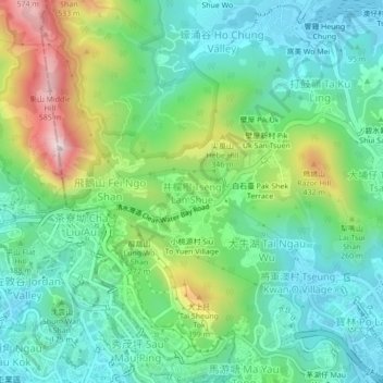
Name: Tseng Lan Shue topographic map, elevation, terrain.
Average elevation: 176 m
Minimum elevation: -1 m
Maximum elevation: 590 m
Other topographic maps
Click on a map to view its topography, its elevation and its terrain.
Long Ke Wan
China > Hong Kong > Sai Kung District
Long Ke Wan, Sai Kung District, New Territories, Hong Kong, China
Average elevation: 70 m
High Island
China > Hong Kong > Sai Kung District
High Island, Sai Kung District, New Territories, Hong Kong, China
Average elevation: 35 m
Pik Shui San Tsuen
China > Hong Kong > Sai Kung District > Tai Po Tsai
Pik Shui San Tsuen, Tai Po Tsai, Sai Kung District, New Territories, Hong Kong, China
Average elevation: 76 m
Devil's Peak
China > Hong Kong > Sai Kung District
Devil's Peak, Sai Kung District, New Territories, Hong Kong, China
Average elevation: 38 m