
Taschachferner topographic map
Interactive map
Click on the map to display elevation.
About this map
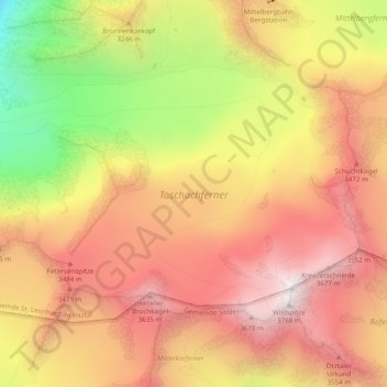
Name: Taschachferner topographic map, elevation, terrain.
Average elevation: 3,193 m
Minimum elevation: 2,379 m
Maximum elevation: 3,733 m
Other topographic maps
Click on a map to view its topography, its elevation and its terrain.
Plangeross
Oostenrijk > Tirol > Bezirk Imst > Gemeinde St. Leonhard im Pitztal
Plangeross, Gemeinde St. Leonhard im Pitztal, Bezirk Imst, Tirol, Oostenrijk
Average elevation: 2,191 m
Mandarfen
Oostenrijk > Tirol > Bezirk Imst > Gemeinde St. Leonhard im Pitztal
Mandarfen, Gemeinde St. Leonhard im Pitztal, Bezirk Imst, Tirol, Oostenrijk
Average elevation: 2,060 m