
Thank you for supporting this site ❤️
Make a donation
Make a donation
Hammer topographic map
Click on the map to display elevation.
Thank you for supporting this site ❤️
Make a donation
Make a donation
About this map
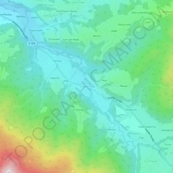
Name: Hammer topographic map, elevation, terrain.
Average elevation: 758 m
Minimum elevation: 612 m
Maximum elevation: 1,208 m
Thank you for supporting this site ❤️
Make a donation
Make a donation
Other topographic maps
Click on a map to view its topography, its elevation and its terrain.
83313
Deutschland > Bayern > Landkreis Traunstein > Siegsdorf > Wolfsberg > Starz
Average elevation: 716 m