Geolocate
👉 Easily get elevation data in JSON, GeoTIFF and KML formats using Elevation API
Thank you for supporting this site ❤️
Make a donation

Cooloola topographic map

Click on the map to display elevation.

👉 Easily get elevation data in JSON, GeoTIFF and KML formats using Elevation API
Thank you for supporting this site ❤️
Make a donation

About this map

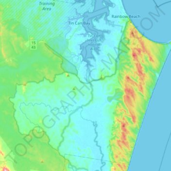
Name: Cooloola topographic map, elevation, terrain.

Location: Cooloola, Gympie Regional, Queensland, Australia (-26.15477 152.86883 -25.88771 153.19151)

Average elevation: 43 m

Minimum elevation: -1 m

Maximum elevation: 309 m

Other topographic maps

Click on a map to view its topography, its elevation and its terrain.

Temple Island

Australia > Queensland

Average elevation: 1 m

Rockhampton

Australia > Queensland

Average elevation: 48 m

Mount Cotton

Australia > Queensland

Average elevation: 105 m

Charters Towers

Australia > Queensland

Average elevation: 302 m

Townsville

Australia > Queensland > Townsville

Average elevation: 30 m