
Thank you for supporting this site ❤️
Make a donation
Make a donation
Loja topographic map
Click on the map to display elevation.
Thank you for supporting this site ❤️
Make a donation
Make a donation
About this map
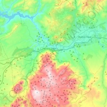
Name: Loja topographic map, elevation, terrain.
Location: Loja, Comarca de Loja, Granada, Andalusia, Spain (37.01234 -4.32762 37.29261 -4.02530)
Average elevation: 810 m
Minimum elevation: 388 m
Maximum elevation: 1,660 m
Thank you for supporting this site ❤️
Make a donation
Make a donation
Other topographic maps
Click on a map to view its topography, its elevation and its terrain.