
Make a donation
Pulau Ular topographic map
Click on the map to display elevation.
Make a donation
About this map
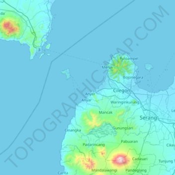
Name: Pulau Ular topographic map, elevation, terrain.
Location: Pulau Ular, Java, Indonesia (-6.32759 105.60796 -5.68759 106.24796)
Average elevation: 67 m
Minimum elevation: -2 m
Maximum elevation: 1,748 m
Make a donation
Other topographic maps
Click on a map to view its topography, its elevation and its terrain.
Special Capital Region of Jakarta
Jakarta lies in a low and flat alluvial plain, ranging from −2 to 91 m (−7 to 299 ft) with an average elevation of 8 m (26 ft) above sea level with historically extensive swampy areas. Some parts of the city have been constructed on reclaimed tidal flats that occur in around the area. Thirteen rivers flow…
Average elevation: 5 m
Make a donation
Semarang
Semarang is located on the northern coast of Java. The city of Semarang is one of the important cities located on the north coast of Java and as the main hub connecting Jakarta and Surabaya, and cities in the southern interior of Java Surakarta and Yogyakarta. Semarang City has a height ranging from 2 m (6.6…
Average elevation: 107 m
Make a donation
East Java
East Java has a tropical monsoon and savanna climate at lower elevation and subtropical at higher elevation. Compared with the western part of Java Island, East Java in general has less rainfall. Average rainfall is 1,900 mm per year, with a rainy season during the 100 days. The average temperature ranges…
Average elevation: 62 m
Lombok
Indonesia > West Nusa Tenggara
The island's topography is dominated by the centrally-located stratovolcano Mount Rinjani, the second-highest volcano in Indonesia, which rises to 3,726 metres (12,224 ft), making Lombok the 8th-highest island. The most recent eruption of Rinjani occurred in September 2016 at Gunung Barujari. In a 2010…
Average elevation: 192 m
Bali
Bali's central mountains include several peaks over 2,000 metres (6,600 feet) in elevation and active volcanoes such as Mount Batur. The highest is Mount Agung (3,031 m, 9,944 ft), known as the "mother mountain", which is an active volcano rated as one of the world's most likely sites for a massive eruption…
Average elevation: 88 m
Make a donation
Pulau Bali
Bali features a diverse topography shaped by a volcanic origin, which significantly influences its landscapes and climate. The island is dominated by a central mountain range that runs from west to east, with Mount Agung, reaching an elevation of approximately 10,308 feet, standing as the highest peak and a…
Average elevation: 122 m
Make a donation
Alun-Alun Ambarawa
Indonesia > Central Java > Kabupaten Semarang > Tambakboyo > Katang
Average elevation: 499 m
Make a donation
Borneo
Before sea levels rose at the end of the last ice age, Borneo was part of the mainland of Asia, forming, with Java and Sumatra, the upland regions of a peninsula that extended east from present day Indochina. The South China Sea and Gulf of Thailand now submerge the former low-lying areas of the peninsula.…
Average elevation: 141 m
Make a donation
Bali
Bali's central mountains include several peaks over 2,000 metres (6,600 feet) in elevation and active volcanoes such as Mount Batur. The highest is Mount Agung (3,031 m; 9,944 ft), known as the "mother mountain", which is an active volcano rated as one of the world's most likely sites for a massive eruption…
Average elevation: 88 m
Make a donation
Make a donation
Make a donation
West Kalimantan
Influenced by the vast lowlands, the heights of the mountains are relatively low as well as non-volcanically active. The highest mountain is Mount Baturaya in Serawai District of Sintang Regency which has an altitude of 2,278 metres above sea level, far lower than Mount Semeru (East Java, 3,676 metres) or…
Average elevation: 92 m
Make a donation
Make a donation
Pecatu
Pecatu is located in South Kuta District of Badung Regency. It is at the western end of the Bukit Peninsula in south Bali, and has a hilly topography with limestone cliffs isolating small, short beaches that have been privately developed. Nusa Dua, on the opposite side of the peninsula, is flat and is a…
Average elevation: 78 m
Make a donation
Make a donation
Make a donation
Kapuas River
The river is 1,143 km (710 mi) long and 99,000 km2 (38,000 mi2) the river basin covers more than 67% of West Kalimantan. The river originates near the center of Borneo, south of the Indonesian-Malaysian border, in the joint between the western slope of the Müller Mountain Range, which runs through the island…
Average elevation: 141 m
Malang
The city was capital city of Singhasari in 1222, then transferred to Dutch colony. Malang was modernized under the Dutch; its mild climate which results from its elevation, along with its proximity to the major port of Surabaya, made it a popular destination for the Dutch and other Europeans. Malang began to…
Average elevation: 490 m
Make a donation
Make a donation
Make a donation
Make a donation
Make a donation
Make a donation
Kelingking Beach
Indonesia > Bali > Klungkung Regency > Bunga Mekar > Karangdewa
Average elevation: 76 m
Make a donation
Make a donation
Make a donation
Make a donation
Make a donation