
Stepps topographic map
Interactive map
Click on the map to display elevation.
About this map
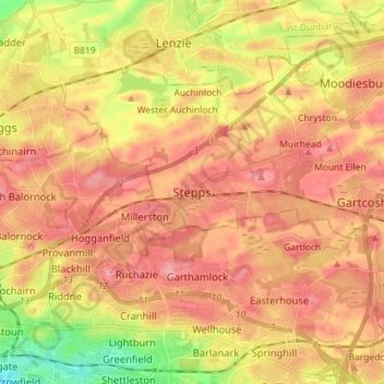
Name: Stepps topographic map, elevation, terrain.
Location: Stepps, North Lanarkshire, Scotland, G33 6HB, United Kingdom (55.85090 -4.18598 55.93090 -4.10598)
Average elevation: 73 m
Minimum elevation: 12 m
Maximum elevation: 111 m
Other topographic maps
Click on a map to view its topography, its elevation and its terrain.
Airdrie
United Kingdom > Scotland > North Lanarkshire
Airdrie, North Lanarkshire, Scotland, ML6 6BU, United Kingdom
Average elevation: 136 m
Newmains
United Kingdom > Scotland > North Lanarkshire > Newmains
Newmains, North Lanarkshire, Scotland, ML2 9EY, United Kingdom
Average elevation: 163 m