
Thank you for supporting this site ❤️
Make a donation
Make a donation
Tala topographic map
Click on the map to display elevation.
Thank you for supporting this site ❤️
Make a donation
Make a donation
About this map
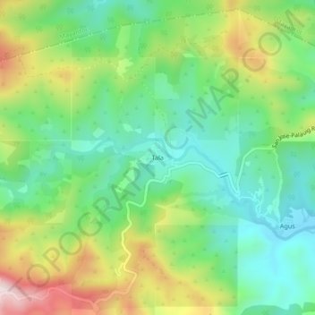
Name: Tala topographic map, elevation, terrain.
Location: Tala, San Jose, Tarlac, Central Luzon, Philippines (15.48446 120.31360 15.52446 120.35360)
Average elevation: 381 m
Minimum elevation: 198 m
Maximum elevation: 713 m
Thank you for supporting this site ❤️
Make a donation
Make a donation
Other topographic maps
Click on a map to view its topography, its elevation and its terrain.