
Thank you for supporting this site ❤️
Make a donation
Make a donation
Rockledge topographic map
Click on the map to display elevation.
Thank you for supporting this site ❤️
Make a donation
Make a donation
About this map
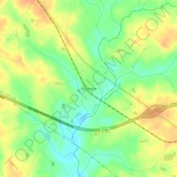
Name: Rockledge topographic map, elevation, terrain.
Location: Rockledge, Laurens County, Georgia, 30454, United States (32.42295 -82.71764 32.46295 -82.67764)
Average elevation: 71 m
Minimum elevation: 49 m
Maximum elevation: 93 m
Thank you for supporting this site ❤️
Make a donation
Make a donation
Other topographic maps
Click on a map to view its topography, its elevation and its terrain.