
Thank you for supporting this site ❤️
Make a donation
Make a donation
Limboro topographic map
Click on the map to display elevation.
Thank you for supporting this site ❤️
Make a donation
Make a donation
About this map
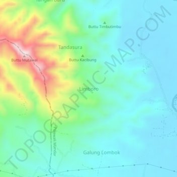
Name: Limboro topographic map, elevation, terrain.
Location: Limboro, Polewali Mandar, West Sulawesi, Sulawesi, Indonesia (-3.49478 118.95381 -3.45478 118.99381)
Average elevation: 127 m
Minimum elevation: 6 m
Maximum elevation: 514 m
Thank you for supporting this site ❤️
Make a donation
Make a donation
Other topographic maps
Click on a map to view its topography, its elevation and its terrain.