
Thank you for supporting this site ❤️
Make a donation
Make a donation
Pryor Creek topographic map
Click on the map to display elevation.
Thank you for supporting this site ❤️
Make a donation
Make a donation
About this map
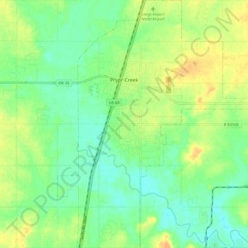
Name: Pryor Creek topographic map, elevation, terrain.
Location: Pryor Creek, Mayes County, Oklahoma, United States (36.24938 -95.34592 36.33632 -95.25620)
Average elevation: 190 m
Minimum elevation: 176 m
Maximum elevation: 209 m
Thank you for supporting this site ❤️
Make a donation
Make a donation
Other topographic maps
Click on a map to view its topography, its elevation and its terrain.
Thank you for supporting this site ❤️
Make a donation
Make a donation
Adair
United States > Oklahoma > Mayes County > Adair
Adair lies 10 miles (16 km) north of Pryor on U.S. Route 69 in Mayes County. The city is in the northeastern portion of the state known as "Green Country" and is near the borders of Kansas, Missouri, and Arkansas. Adair's geographic coordinates are 36°26′13″N 95°15′45″W / 36.43694°N…
Average elevation: 206 m
Thank you for supporting this site ❤️
Make a donation
Make a donation