
Thank you for supporting this site ❤️
Make a donation
Make a donation
Grândola topographic map
Click on the map to display elevation.
Thank you for supporting this site ❤️
Make a donation
Make a donation
Grândola
Significant civic and religious infrastructure was developed after the town's elevation, including the construction of a town hall, a jail, a pillory, a hospital, a Santa Casa da Misericórdia, and several chapels and churches. A common granary was established in 1579 to provide low-interest seed loans to poor farmers, operating until around 1880.
Thank you for supporting this site ❤️
Make a donation
Make a donation
About this map
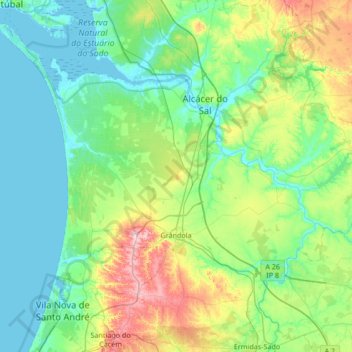
Name: Grândola topographic map, elevation, terrain.
Location: Grândola, Setúbal, Portugal (38.02345 -8.91287 38.50534 -8.23818)
Average elevation: 69 m
Minimum elevation: -3 m
Maximum elevation: 319 m
Thank you for supporting this site ❤️
Make a donation
Make a donation
Other topographic maps
Click on a map to view its topography, its elevation and its terrain.
Thank you for supporting this site ❤️
Make a donation
Make a donation
Thank you for supporting this site ❤️
Make a donation
Make a donation
Thank you for supporting this site ❤️
Make a donation
Make a donation
Thank you for supporting this site ❤️
Make a donation
Make a donation
Charneca de Caparica
Portugal > Setúbal > Charneca de Caparica e Sobreda > Charneca de Caparica
Average elevation: 40 m
Thank you for supporting this site ❤️
Make a donation
Make a donation