
Thank you for supporting this site ❤️
Make a donation
Make a donation
Sanganer topographic map
Click on the map to display elevation.
Thank you for supporting this site ❤️
Make a donation
Make a donation
About this map
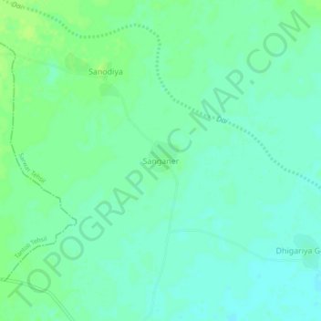
Name: Sanganer topographic map, elevation, terrain.
Location: Sanganer, Sarwar Tehsil, Ajmer, Rajasthan, India (26.07363 74.91053 26.11363 74.95053)
Average elevation: 361 m
Minimum elevation: 355 m
Maximum elevation: 366 m
Thank you for supporting this site ❤️
Make a donation
Make a donation