
Thank you for supporting this site ❤️
Make a donation
Make a donation
Larzey topographic map
Click on the map to display elevation.
Thank you for supporting this site ❤️
Make a donation
Make a donation
About this map
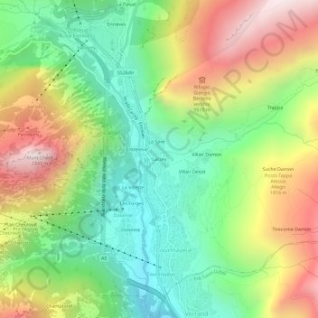
Name: Larzey topographic map, elevation, terrain.
Location: Larzey, Courmayeur, Aosta Valley, 11013, Italy (45.77887 6.95038 45.81887 6.99038)
Average elevation: 1,596 m
Minimum elevation: 1,095 m
Maximum elevation: 2,320 m
Thank you for supporting this site ❤️
Make a donation
Make a donation
Other topographic maps
Click on a map to view its topography, its elevation and its terrain.