
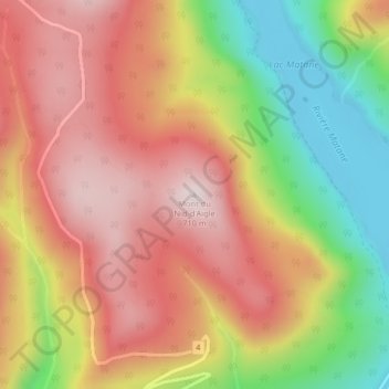
Mont du Nid-d'Aigle topographic map
Interactive map
Click on the map to display elevation.
About this map
Name: Mont du Nid-d'Aigle topographic map, elevation, terrain.
Average elevation: 498 m
Minimum elevation: 216 m
Maximum elevation: 717 m
Other topographic maps
Click on a map to view its topography, its elevation and its terrain.
Lac Paul
Canada > Québec > La Matanie > Rivière-Bonjour
Lac Paul, Rivière-Bonjour, La Matanie, Bas-Saint-Laurent, Québec, Canada
Average elevation: 578 m
Mont Pointu
Canada > Québec > La Matanie > Rivière-Bonjour
Mont Pointu, Rivière-Bonjour, La Matanie, Bas-Saint-Laurent, Québec, Canada
Average elevation: 649 m