
Chepstow topographic map
Interactive map
Click on the map to display elevation.
About this map
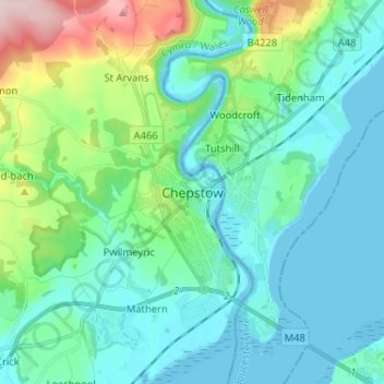
Name: Chepstow topographic map, elevation, terrain.
Location: Chepstow, Monmouthshire, Pays de Galles, NP16 5DB, Royaume-Uni (51.60093 -2.71669 51.68093 -2.63669)
Average elevation: 57 m
Minimum elevation: -12 m
Maximum elevation: 285 m
Other topographic maps
Click on a map to view its topography, its elevation and its terrain.
Monmouth
Royaume-Uni > Pays de Galles > Monmouthshire
Monmouth, Monmouthshire, Pays de Galles, NP25 3UZ, Royaume-Uni
Average elevation: 101 m