
Thank you for supporting this site ❤️
Make a donation
Make a donation
Mount Yangbew topographic map
Click on the map to display elevation.
Thank you for supporting this site ❤️
Make a donation
Make a donation
About this map
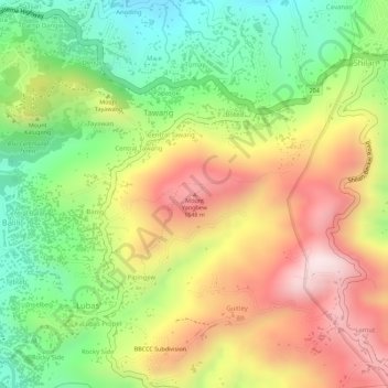
Name: Mount Yangbew topographic map, elevation, terrain.
Average elevation: 1,473 m
Minimum elevation: 1,244 m
Maximum elevation: 1,702 m
Thank you for supporting this site ❤️
Make a donation
Make a donation
Other topographic maps
Click on a map to view its topography, its elevation and its terrain.
Wangal, La Trinidad, Benguet
Philippines > Benguet > La Trinidad > Wangal > Ampasit
Average elevation: 1,352 m
Thank you for supporting this site ❤️
Make a donation
Make a donation