
Ribadeo topographic map
Interactive map
Click on the map to display elevation.
About this map
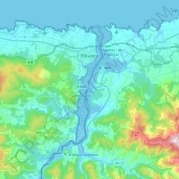
Name: Ribadeo topographic map, elevation, terrain.
Location: Ribadeo, A Mariña Oriental, Lugo, Galice, Espagne (43.46123 -7.20870 43.56169 -7.03016)
Average elevation: 127 m
Minimum elevation: -4 m
Maximum elevation: 556 m
Other topographic maps
Click on a map to view its topography, its elevation and its terrain.
Cei
Espagne > Galice > A Mariña Oriental
Cei, Arante, Ribadeo, A Mariña Oriental, Lugo, Galice, 27710, Espagne
Average elevation: 282 m
Francas
Espagne > Galice > A Mariña Oriental > Trabada
Francas, A Valboa, Trabada, A Mariña Oriental, Lugo, Galice, 27766, Espagne
Average elevation: 201 m
A Panturreira
Espagne > Galice > A Mariña Oriental > A Pontenova
A Panturreira, Vilaboa, A Pontenova, A Mariña Oriental, Lugo, Galice, 27721, Espagne
Average elevation: 288 m