
Wartberg an der Krems topographic map
Interactive map
Click on the map to display elevation.
About this map
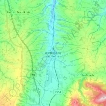
Name: Wartberg an der Krems topographic map, elevation, terrain.
Location: Wartberg an der Krems, Bezirk Kirchdorf, 4552, Österreich (47.96103 14.04518 48.02033 14.17945)
Average elevation: 462 m
Minimum elevation: 353 m
Maximum elevation: 752 m
Other topographic maps
Click on a map to view its topography, its elevation and its terrain.
Pettenbach
Pettenbach, Bezirk Kirchdorf, 4643, Österreich
Average elevation: 518 m
Edlbach
Edlbach, Bezirk Kirchdorf, 4580, Österreich
Average elevation: 675 m
Spital am Pyhrn
Spital am Pyhrn, Bezirk Kirchdorf, 4582, Österreich
Average elevation: 1,106 m
Windischgarsten
Windischgarsten, Bezirk Kirchdorf, 4580, Österreich
Average elevation: 660 m
Großer Priel
Österreich > Bezirk Kirchdorf > Hinterstoder
Großer Priel, Hinterstoder, Bezirk Kirchdorf, 4573, Österreich
Average elevation: 1,919 m
Steinbach an der Steyr
Steinbach an der Steyr, Bezirk Kirchdorf, 4596, Österreich
Average elevation: 543 m