
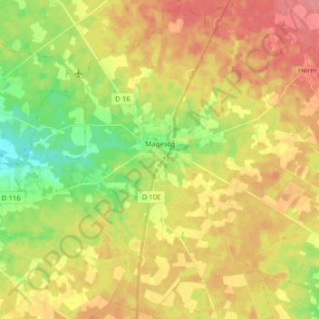
Magescq topographic map
Interactive map
Click on the map to display elevation.
About this map
Name: Magescq topographic map, elevation, terrain.
Average elevation: 42 m
Minimum elevation: 4 m
Maximum elevation: 75 m
Other topographic maps
Click on a map to view its topography, its elevation and its terrain.
Pissos
France > Nouvelle-Aquitaine > Landes
Pissos, Mont-de-Marsan, Landes, Nouvelle-Aquitaine, France métropolitaine, 40410, France
Average elevation: 62 m
Saint-Geours-de-Maremne
France > Nouvelle-Aquitaine > Landes
Saint-Geours-de-Maremne, Dax, Landes, Nouvelle-Aquitaine, France métropolitaine, 40230, France
Average elevation: 34 m
Le Balasson
France > Nouvelle-Aquitaine > Landes > Meilhan
Le Balasson, Meilhan, Arrondissement de Dax, Landes, Nouvelle-Aquitaine, France métropolitaine, 40400, France
Average elevation: 62 m
Petit Étang de Biscarosse
France > Nouvelle-Aquitaine > Landes > Biscarrosse > Trappe
Petit Étang de Biscarosse, Trappe, Biscarrosse, Mont-de-Marsan, Landes, Nouvelle-Aquitaine, France métropolitaine, 40600, France
Average elevation: 24 m