
Golden topographic map
Interactive map
Click on the map to display elevation.
About this map
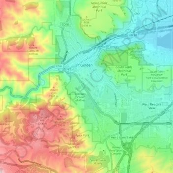
Name: Golden topographic map, elevation, terrain.
Location: Golden, Jefferson County, Colorado, États-Unis d'Amérique (39.70061 -105.24196 39.78711 -105.16186)
Average elevation: 1,936 m
Minimum elevation: 1,673 m
Maximum elevation: 2,415 m
Other topographic maps
Click on a map to view its topography, its elevation and its terrain.
Lakewood
États-Unis d'Amérique > Colorado > Jefferson County
Lakewood, Jefferson County, Colorado, États-Unis d'Amérique
Average elevation: 1,690 m