
Semarang topographic map
Interactive map
Click on the map to display elevation.
About this map
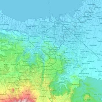
Name: Semarang topographic map, elevation, terrain.
Location: Semarang, Jateng, Indonesië (-7.11446 110.26729 -6.93199 110.50888)
Average elevation: 110 m
Minimum elevation: -1 m
Maximum elevation: 813 m
Other topographic maps
Click on a map to view its topography, its elevation and its terrain.
Purwokerto
Indonesië > Jateng > Purwokerto
Purwokerto, Banyumas, Jateng, 53116, Indonesië
Average elevation: 277 m
Puncak Trianggulasi
Puncak Trianggulasi, Jrakah, Jateng, Indonesië
Average elevation: 2,696 m