
Blignou (Ayent) topographic map
Interactive map
Click on the map to display elevation.
About this map
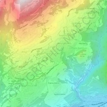
Name: Blignou (Ayent) topographic map, elevation, terrain.
Location: Blignou (Ayent), Ayent, Hérens, Valais, 1966, Suisse (46.25268 7.37915 46.29268 7.41915)
Average elevation: 976 m
Minimum elevation: 496 m
Maximum elevation: 1,776 m
Other topographic maps
Click on a map to view its topography, its elevation and its terrain.
Les Routesses
Suisse > Valais > Hérens > Ayent > Fortunau (Ayent)
Les Routesses, Fortunau (Ayent), Ayent, Hérens, Valais, 1966, Suisse
Average elevation: 1,158 m
Saint-Romain
Suisse > Valais > Hérens > Ayent
Saint-Romain, Ayent, Hérens, Valais, 1966, Suisse
Average elevation: 1,103 m