
Make a donation
Castile-La Mancha topographic map
Click on the map to display elevation.
Make a donation
About this map
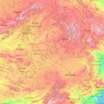
Name: Castile-La Mancha topographic map, elevation, terrain.
Location: Castile-La Mancha, Spain (38.02244 -5.40618 41.32763 -0.91579)
Average elevation: 823 m
Minimum elevation: -4 m
Maximum elevation: 2,315 m
Make a donation
Other topographic maps
Click on a map to view its topography, its elevation and its terrain.
Masca
Masca is a small mountain village on the island of Tenerife. It was originally a Guanche settlement before the Spanish conquest in 1496. The village is now home to around 90 inhabitants. The village lies at an altitude of 650 m in the Macizo de Teno mountains, which extend up to the northwesternmost point of…
Average elevation: 769 m
Make a donation
Make a donation
Make a donation
Madrid
Spain > Community of Madrid > Área metropolitana de Madrid y Corredor del Henares > Madrid
Average elevation: 650 m