
Mar Chiquita topographic map
Interactive map
Click on the map to display elevation.
About this map
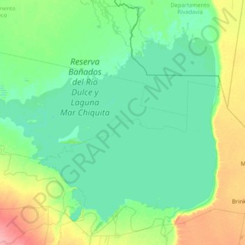
Name: Mar Chiquita topographic map, elevation, terrain.
Location: Mar Chiquita, Córdoba, Argentina (-30.95426 -63.36601 -30.12175 -62.18459)
Average elevation: 78 m
Minimum elevation: 66 m
Maximum elevation: 134 m
There are several islands in the lake, the most important one being the Médano Island. Mar Chiquita is slowly diminishing in volume due to increased evaporation and elevation of its bottom, and is ultimately bound to turn into a salt flat. According to the Mono Lake Committee, Aves Argentinas and Argentina Natura International are attempting to establish "the largest National Park in Argentina at Laguna Mar Chiquita, the" (northern) "winter home to large concentrations of Wilson's Phalaropes." The lake was formerly home to a growing tourism industry, and was the site of the Gran Hotel Viena [es], a luxurious, lakefront establishment which functioned from 1945 to 1980, and has been the center of numerous mysteries and controversies.
Other topographic maps
Click on a map to view its topography, its elevation and its terrain.
Gran Córdoba
Argentina > Córdoba > Pedanía San Vicente
Gran Córdoba, Pedanía San Vicente, Departamento Colón, Córdoba, X5111, Argentina
Average elevation: 549 m
La Cascada
Argentina > Córdoba > La Cascada
La Cascada, Municipio de Almafuerte, Pedanía Salto, Departamento Tercero Arriba, Córdoba, X5980, Argentina
Average elevation: 430 m
Quebrada de las Rosas
Quebrada de las Rosas, Cordoba, Municipio de Córdoba, Pedanía Capital, Departamento Capital, Córdoba, X5003, Argentina
Average elevation: 447 m