
Thank you for supporting this site ❤️
Make a donation
Make a donation
Zöschen topographic map
Click on the map to display elevation.
Thank you for supporting this site ❤️
Make a donation
Make a donation
Zöschen
Ein kultureller Höhepunkt im dörflichen Leben ist das jährliche „Kuchenessen“ (14 Tage nach Pfingsten), ein Heimat- und Volksfest, welches seit Jahrhunderten stattfindet.
Thank you for supporting this site ❤️
Make a donation
Make a donation
About this map
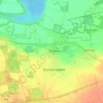
Name: Zöschen topographic map, elevation, terrain.
Location: Zöschen, Leuna, Saalekreis, Sachsen-Anhalt, Deutschland (51.33451 12.09606 51.37321 12.13748)
Average elevation: 97 m
Minimum elevation: 78 m
Maximum elevation: 116 m
Thank you for supporting this site ❤️
Make a donation
Make a donation
Other topographic maps
Click on a map to view its topography, its elevation and its terrain.