
Thank you for supporting this site ❤️
Make a donation
Make a donation
Maqhaka topographic map
Click on the map to display elevation.
Thank you for supporting this site ❤️
Make a donation
Make a donation
About this map
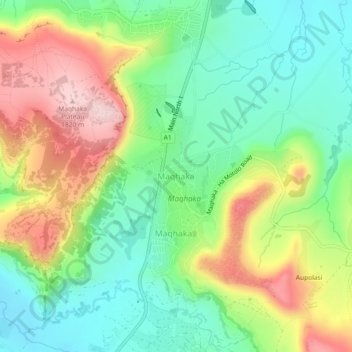
Name: Maqhaka topographic map, elevation, terrain.
Location: Maqhaka, Berea District, Lesotho (-29.26600 27.58678 -29.22600 27.62678)
Average elevation: 1,649 m
Minimum elevation: 1,539 m
Maximum elevation: 1,820 m
Thank you for supporting this site ❤️
Make a donation
Make a donation
Other topographic maps
Click on a map to view its topography, its elevation and its terrain.