
Thank you for supporting this site ❤️
Make a donation
Make a donation
Penwortham topographic map
Click on the map to display elevation.
Thank you for supporting this site ❤️
Make a donation
Make a donation
About this map
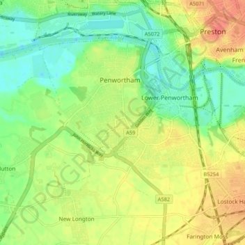
Name: Penwortham topographic map, elevation, terrain.
Location: Penwortham, South Ribble, Lancashire, England, United Kingdom (53.72524 -2.77452 53.75763 -2.69306)
Average elevation: 23 m
Minimum elevation: 1 m
Maximum elevation: 48 m
Thank you for supporting this site ❤️
Make a donation
Make a donation