
Thank you for supporting this site ❤️
Make a donation
Make a donation
Cheras topographic map
Click on the map to display elevation.
Thank you for supporting this site ❤️
Make a donation
Make a donation
About this map
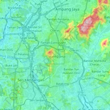
Name: Cheras topographic map, elevation, terrain.
Location: Cheras, Kuala Lumpur, Malaysia (2.99460 101.70600 3.13905 101.80236)
Average elevation: 74 m
Minimum elevation: 12 m
Maximum elevation: 399 m
Thank you for supporting this site ❤️
Make a donation
Make a donation
Other topographic maps
Click on a map to view its topography, its elevation and its terrain.