
Thank you for supporting this site ❤️
Make a donation
Make a donation
Denneville Plage topographic map
Click on the map to display elevation.
Thank you for supporting this site ❤️
Make a donation
Make a donation
About this map
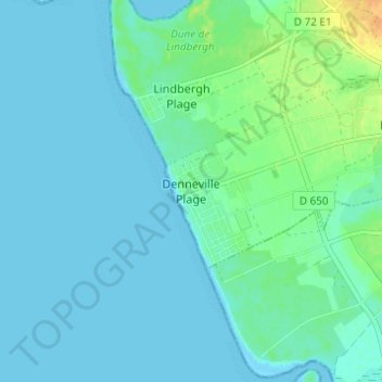
Name: Denneville Plage topographic map, elevation, terrain.
Average elevation: 6 m
Minimum elevation: 0 m
Maximum elevation: 27 m
Thank you for supporting this site ❤️
Make a donation
Make a donation
Other topographic maps
Click on a map to view its topography, its elevation and its terrain.
50580
France > Normandie > Manche > Port-Bail-sur-Mer > Saint-Lô-d'Ourville > Village de la Die
Average elevation: 24 m
Thank you for supporting this site ❤️
Make a donation
Make a donation