
Thank you for supporting this site ❤️
Make a donation
Make a donation
Lac de Viremont topographic map
Click on the map to display elevation.
Thank you for supporting this site ❤️
Make a donation
Make a donation
Lac de Viremont
Ce lac, à 656 m d'altitude, d'une superficie de 2 ha, d'une profondeur maximale de 4 m, est situé dans une zone naturelle d'intérêt écologique, faunistique et floristique d'origine glaciaire .
Thank you for supporting this site ❤️
Make a donation
Make a donation
About this map
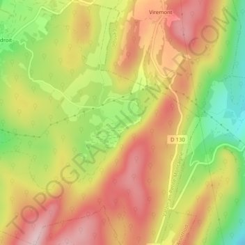
Name: Lac de Viremont topographic map, elevation, terrain.
Average elevation: 691 m
Minimum elevation: 551 m
Maximum elevation: 801 m
Thank you for supporting this site ❤️
Make a donation
Make a donation
Other topographic maps
Click on a map to view its topography, its elevation and its terrain.
Chatonnay
France > Bourgogne-Franche-Comté > Jura > Valzin-en-Petite-Montagne
Average elevation: 394 m
Thank you for supporting this site ❤️
Make a donation
Make a donation
Montadroit
France > Bourgogne-Franche-Comté > Jura > Valzin-en-Petite-Montagne
Average elevation: 584 m