
Make a donation
Andorf topographic map
Click on the map to display elevation.
Make a donation
Andorf
Andorf liegt auf 346 m Höhe im Innviertel. Die Ausdehnung beträgt von Nord nach Süd 7,7 km, von West nach Ost 7,6 km. Die Gesamtfläche beträgt 37,6 km². 12,8 % der Fläche sind bewaldet, 75 % der Fläche sind landwirtschaftlich genutzt.
Make a donation
About this map
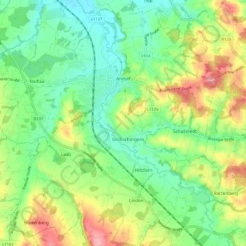
Name: Andorf topographic map, elevation, terrain.
Location: Andorf, Bezirk Schärding, Oberösterreich, 4770, Österreich (48.32632 13.51476 48.39451 13.61876)
Average elevation: 373 m
Minimum elevation: 330 m
Maximum elevation: 444 m
Make a donation
Other topographic maps
Click on a map to view its topography, its elevation and its terrain.
Stocket
Österreich > Oberösterreich > Bezirk Schärding > St. Marienkirchen bei Schärding
Average elevation: 332 m
Make a donation
Atzmanning
Österreich > Oberösterreich > Bezirk Schärding > Brunnenthal > Atzmanning
Average elevation: 456 m
Make a donation