
Make a donation
Kassel topographic map
Click on the map to display elevation.
Make a donation
About this map
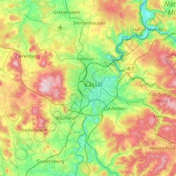
Name: Kassel topographic map, elevation, terrain.
Location: Kassel, Hessen, 34117, Deutschland (51.15545 9.33241 51.47545 9.65241)
Average elevation: 296 m
Minimum elevation: 113 m
Maximum elevation: 620 m
Make a donation
Other topographic maps
Click on a map to view its topography, its elevation and its terrain.
Niederzwehren
Deutschland > Hessen > Kassel
Nach Norden hin wird Niederzwehren in Richtung Park Schönfeld und Wehlheiden durch die nach Wilhelmshöhe abzweigende Verbindung der Waldkappeler Bahn begrenzt.
Average elevation: 173 m
Karlsaue
Deutschland > Hessen > Kassel
In der Nähe des Sees steht eine Stieleiche mit einem Brusthöhenumfang von 7,95 m (2015).
Average elevation: 152 m
Make a donation
Make a donation
Bad Wilhelmshöhe
Deutschland > Hessen > Kassel
Bad Wilhelmshöhe (bis 2002 Wilhelmshöhe, auch Kassel-Wilhelmshöhe genannt) ist seit dem 1. Juli 1906 ein Stadtteil der nordhessischen Stadt Kassel. Seit 2002 ist der Stadtteil ein staatlich anerkanntes Heilbad und Kneippheilbad.
Average elevation: 285 m