
Make a donation
Ebenfurth topographic map
Click on the map to display elevation.
Make a donation
Ebenfurth
Vor Christi Geburt war das Gebiet Teil des keltischen Königreiches Noricum und gehörte zur Umgebung der keltischen Höhensiedlung Burg auf dem Schwarzenbacher Burgberg.
Make a donation
About this map
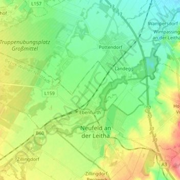
Name: Ebenfurth topographic map, elevation, terrain.
Average elevation: 230 m
Minimum elevation: 203 m
Maximum elevation: 278 m
Make a donation
Other topographic maps
Click on a map to view its topography, its elevation and its terrain.
Muthmannsdorf
Österreich > Niederösterreich > Bezirk Wiener Neustadt > Winzendorf-Muthmannsdorf
Average elevation: 469 m
Hofstätten
Österreich > Niederösterreich > Bezirk Wiener Neustadt > Gemeinde Bromberg > Bromberg
Average elevation: 508 m
Alm
Österreich > Niederösterreich > Bezirk Wiener Neustadt > Gemeinde Hochwolkersdorf > Hochwolkersdorf
Average elevation: 595 m
Make a donation
Bad Erlach
Österreich > Niederösterreich > Bezirk Wiener Neustadt > Gemeinde Bad Erlach
Average elevation: 343 m
Kreuth
Österreich > Niederösterreich > Bezirk Wiener Neustadt > Gemeinde Muggendorf > Kreuth
Average elevation: 683 m
Steinabrückl
Österreich > Niederösterreich > Bezirk Wiener Neustadt > Gemeinde Wöllersdorf-Steinabrückl
Average elevation: 317 m
Schober
Österreich > Niederösterreich > Bezirk Wiener Neustadt > Gemeinde Gutenstein
Average elevation: 904 m
Make a donation
Vorderbruck
Österreich > Niederösterreich > Bezirk Wiener Neustadt > Gemeinde Gutenstein > Gutenstein
Average elevation: 614 m