
Thank you for supporting this site ❤️
Make a donation
Make a donation
Osmotherley topographic map
Click on the map to display elevation.
Thank you for supporting this site ❤️
Make a donation
Make a donation
About this map
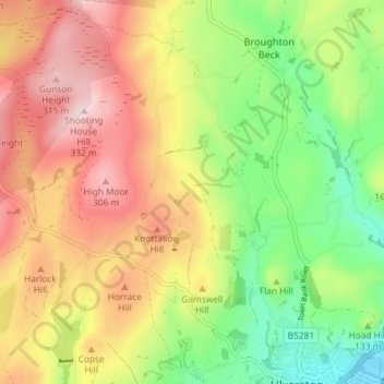
Name: Osmotherley topographic map, elevation, terrain.
Location: Osmotherley, Westmorland and Furness, England, United Kingdom (54.19599 -3.13711 54.23858 -3.09539)
Average elevation: 163 m
Minimum elevation: 7 m
Maximum elevation: 331 m
Thank you for supporting this site ❤️
Make a donation
Make a donation
Other topographic maps
Click on a map to view its topography, its elevation and its terrain.