
Make a donation
Matupi Township topographic map
Click on the map to display elevation.
Make a donation
Matupi Township
Agriculture is the most essential and profitable industry in the Matupi Township, employing more than 90% of the population. Common crops include rice, wheat, corn, millet, pulses, oilseeds, coffee, oranges, damson, potatoes, and natural fibres. However, Matupi still depends on the import of rice supplies from the lowlands. Although the primary occupation is agriculture, the industry is not well developed due to the scarcity of large valleys and plains. Shifting cultivation is still prevalent. Terraced cultivation is slowly being introduced along the hillsides. Due to difficult terrain, human labor is the main driving force of the work done. Teak and other hardwoods are found at elevation below 900 metres (3,000 ft). Oaks and pines grow at altitudes above 900 metres (3,000 ft). Teak, pines, canes, resin and turpentine are important forest products. Since electricity is not available in most villages, people depend on firewood for cooking. Forestry is also a main source of income.
Make a donation
About this map
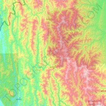
Name: Matupi Township topographic map, elevation, terrain.
Location: Matupi Township, Mindat District, Chin, Myanmar (21.23314 93.01471 22.23019 94.01750)
Average elevation: 940 m
Minimum elevation: 4 m
Maximum elevation: 2,772 m
Make a donation
Other topographic maps
Click on a map to view its topography, its elevation and its terrain.