
Thank you for supporting this site ❤️
Make a donation
Make a donation
Carlton Landing topographic map
Click on the map to display elevation.
Thank you for supporting this site ❤️
Make a donation
Make a donation
About this map
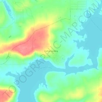
Name: Carlton Landing topographic map, elevation, terrain.
Location: Carlton Landing, Pittsburg County, Oklahoma, United States (35.18816 -95.56853 35.22816 -95.52853)
Average elevation: 200 m
Minimum elevation: 175 m
Maximum elevation: 252 m
Thank you for supporting this site ❤️
Make a donation
Make a donation
Other topographic maps
Click on a map to view its topography, its elevation and its terrain.