
Make a donation
Trout Lake topographic map
Click on the map to display elevation.
Make a donation
About this map
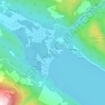
Name: Trout Lake topographic map, elevation, terrain.
Average elevation: 823 m
Minimum elevation: 711 m
Maximum elevation: 1,513 m
Make a donation
Other topographic maps
Click on a map to view its topography, its elevation and its terrain.
Upper Arrow Lake
Canada > British Columbia > Columbia-Shuswap Regional District > Area B (Shelter Bay/Mica Creek)
Average elevation: 1,462 m
Revy Riders Moto Trails Recreation Site
Canada > British Columbia > Columbia-Shuswap Regional District > Area B (Shelter Bay/Mica Creek)
Average elevation: 1,210 m
Galena Bay
Canada > British Columbia > Columbia-Shuswap Regional District > Area B (Shelter Bay/Mica Creek)
Average elevation: 489 m
Illecillewaet Glacier
Canada > British Columbia > Columbia-Shuswap Regional District > Area B (Shelter Bay/Mica Creek)
Average elevation: 2,413 m
Make a donation
Asulkan Glacier
Canada > British Columbia > Columbia-Shuswap Regional District > Area B (Shelter Bay/Mica Creek)
Average elevation: 2,304 m
Bonney Glacier
Canada > British Columbia > Columbia-Shuswap Regional District > Area B (Shelter Bay/Mica Creek)
Average elevation: 2,295 m
Bear Glacier
Canada > British Columbia > Columbia-Shuswap Regional District > Area B (Shelter Bay/Mica Creek)
Average elevation: 2,266 m
Mount Revelstoke National Park
Canada > British Columbia > Columbia-Shuswap Regional District > Area B (Shelter Bay/Mica Creek)
Average elevation: 1,477 m
Make a donation