
Thank you for supporting this site ❤️
Make a donation
Make a donation
Kasekere-kawala topographic map
Click on the map to display elevation.
Thank you for supporting this site ❤️
Make a donation
Make a donation
About this map
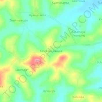
Name: Kasekere-kawala topographic map, elevation, terrain.
Location: Kasekere-kawala, Kassanda, Central Region, Uganda (0.52767 31.74294 0.56767 31.78294)
Average elevation: 1,248 m
Minimum elevation: 1,208 m
Maximum elevation: 1,324 m
Thank you for supporting this site ❤️
Make a donation
Make a donation