
Thank you for supporting this site ❤️
Make a donation
Make a donation
Henneberg topographic map
Click on the map to display elevation.
Thank you for supporting this site ❤️
Make a donation
Make a donation
About this map
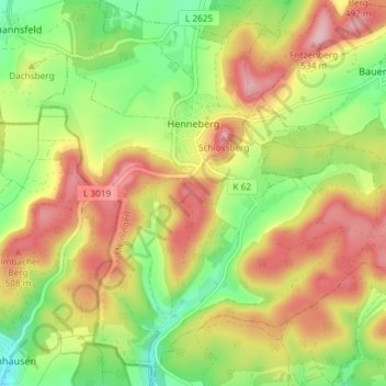
Name: Henneberg topographic map, elevation, terrain.
Average elevation: 427 m
Minimum elevation: 333 m
Maximum elevation: 528 m
Thank you for supporting this site ❤️
Make a donation
Make a donation
Other topographic maps
Click on a map to view its topography, its elevation and its terrain.
Träbes
Deutschland > Thüringen > Landkreis Schmalkalden-Meiningen > Meiningen
Average elevation: 529 m
Hakenberg
Deutschland > Thüringen > Landkreis Schmalkalden-Meiningen > Meiningen
Average elevation: 401 m
Bielstein
Deutschland > Thüringen > Landkreis Schmalkalden-Meiningen > Meiningen
Average elevation: 361 m