
Thank you for supporting this site ❤️
Make a donation
Make a donation
Le Petit Lanjouan topographic map
Click on the map to display elevation.
Thank you for supporting this site ❤️
Make a donation
Make a donation
About this map
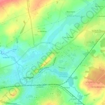
Name: Le Petit Lanjouan topographic map, elevation, terrain.
Average elevation: 66 m
Minimum elevation: 40 m
Maximum elevation: 106 m
Thank you for supporting this site ❤️
Make a donation
Make a donation
Other topographic maps
Click on a map to view its topography, its elevation and its terrain.
Meslin
France > Bretagne > Côtes-d'Armor > Lamballe-Armor
L'altitude moyenne est de 70 mètres et le climat océanique.
Average elevation: 66 m
Thank you for supporting this site ❤️
Make a donation
Make a donation