
Thank you for supporting this site ❤️
Make a donation
Make a donation
La Grande Ruine topographic map
Click on the map to display elevation.
Thank you for supporting this site ❤️
Make a donation
Make a donation
About this map
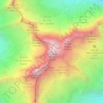
Name: La Grande Ruine topographic map, elevation, terrain.
Average elevation: 3,067 m
Minimum elevation: 2,446 m
Maximum elevation: 3,733 m
Thank you for supporting this site ❤️
Make a donation
Make a donation
Other topographic maps
Click on a map to view its topography, its elevation and its terrain.
Glacier d'Arsine
France > Provence-Alpes-Côte d'Azur > Hautes-Alpes > Villar-d'Arêne
Average elevation: 2,851 m
Jardin botanique alpin du Lautaret
France > Provence-Alpes-Côte d'Azur > Hautes-Alpes > Villar-d'Arêne
Le jardin botanique du col du Lautaret est un jardin botanique alpin d'altitude (2 100 mètres) du massif alpin, situé au col du Lautaret, sur le territoire de la commune de Villar-d'Arêne, dans le département français des Hautes-Alpes. Il est l'un des plus anciens jardins botaniques alpins d'Europe.
Average elevation: 2,177 m