
Thank you for supporting this site ❤️
Make a donation
Make a donation
Arveyes topographic map
Click on the map to display elevation.
Thank you for supporting this site ❤️
Make a donation
Make a donation
About this map
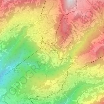
Name: Arveyes topographic map, elevation, terrain.
Location: Arveyes, Ollon VD, District d'Aigle, Vaud, 1884, Suisse (46.27055 7.04177 46.31055 7.08177)
Average elevation: 1,223 m
Minimum elevation: 662 m
Maximum elevation: 1,745 m
Thank you for supporting this site ❤️
Make a donation
Make a donation
Other topographic maps
Click on a map to view its topography, its elevation and its terrain.
Roche (VD)
Suisse > Vaud > District d'Aigle
Roche est située dans la plaine du Rhône, au pied de l'extrémité sud-est du mont d'Arvel et en face du Grammont, sur la rive gauche de l'Eau Froide, à 385 m d'altitude. Elle est à 5 km au nord-ouest d'Aigle.
Average elevation: 593 m
Thank you for supporting this site ❤️
Make a donation
Make a donation