
Da Lat City topographic map
Interactive map
Click on the map to display elevation.
About this map
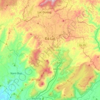
Name: Da Lat City topographic map, elevation, terrain.
Location: Da Lat City, Lâm Đồng Province, Vietnam (11.80765 108.31478 12.00771 108.59257)
Average elevation: 1,322 m
Minimum elevation: 833 m
Maximum elevation: 2,076 m
Other topographic maps
Click on a map to view its topography, its elevation and its terrain.
Bảo Lộc
Vietnam > Lâm Đồng Province > Bảo Lộc
Bảo Lộc, Lâm Đồng Province, 760000, Vietnam
Average elevation: 815 m