
Thank you for supporting this site ❤️
Make a donation
Make a donation
La Rumorosa topographic map
Click on the map to display elevation.
Thank you for supporting this site ❤️
Make a donation
Make a donation
About this map
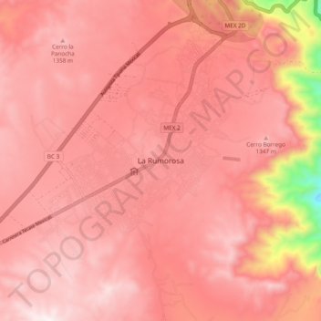
Name: La Rumorosa topographic map, elevation, terrain.
Location: La Rumorosa, Municipio de Tecate, Baja California, Mexico (32.48456 -116.09687 32.56456 -116.01687)
Average elevation: 1,241 m
Minimum elevation: 591 m
Maximum elevation: 1,445 m
Thank you for supporting this site ❤️
Make a donation
Make a donation
Other topographic maps
Click on a map to view its topography, its elevation and its terrain.
Tecate
Mexico > Baja California > Municipio de Tecate
Tecate's altitude of approximately 540 m (1,770 ft) above sea level and its proximity to the ocean contribute to the temperate climate. It rains enough in the area (almost 360 mm [14 in] per year) for a thick ground cover of shrubs and scattered trees to grow.
Average elevation: 595 m