
Make a donation
Pulicciano topographic map
Click on the map to display elevation.
Make a donation
About this map
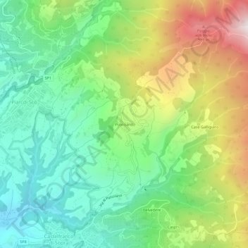
Name: Pulicciano topographic map, elevation, terrain.
Average elevation: 516 m
Minimum elevation: 172 m
Maximum elevation: 1,134 m
Make a donation
Other topographic maps
Click on a map to view its topography, its elevation and its terrain.
Cortona
The prevailing character of Cortona's architecture is medieval with steep narrow streets situated on a hillside at an elevation of 600 metres (2,000 ft) that embraces a view of the whole of the Valdichiana. From the Piazza Garibaldi (still referred to by the local population by its older name, Piazza…
Average elevation: 375 m
Make a donation