
Saint-Sixte topographic map
Interactive map
Click on the map to display elevation.
About this map
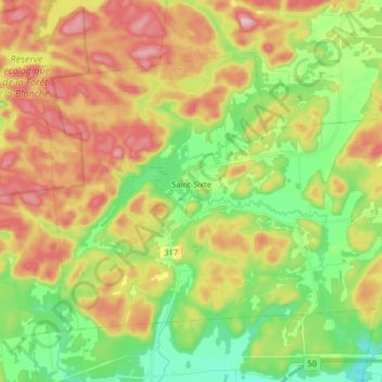
Name: Saint-Sixte topographic map, elevation, terrain.
Location: Saint-Sixte, Papineau, Outaouais, Québec, Canada (45.65507 -75.27324 45.73801 -75.11029)
Average elevation: 196 m
Minimum elevation: 76 m
Maximum elevation: 352 m
Other topographic maps
Click on a map to view its topography, its elevation and its terrain.
Lac Farrand
Canada > Québec > Papineau > Saint-Sixte
Lac Farrand, Saint-Sixte, Papineau, Outaouais, Québec, Canada
Average elevation: 224 m