
Windermere Island topographic map
Interactive map
Click on the map to display elevation.
About this map
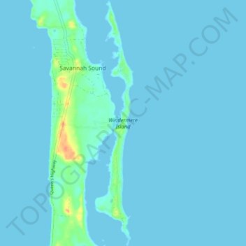
Name: Windermere Island topographic map, elevation, terrain.
Location: Windermere Island, Central Eleuthera, The Bahamas (25.03481 -76.12671 25.10605 -76.11428)
Average elevation: 3 m
Minimum elevation: 0 m
Maximum elevation: 39 m
Other topographic maps
Click on a map to view its topography, its elevation and its terrain.
North Palmetto Point
The Bahamas > Central Eleuthera
North Palmetto Point, Central Eleuthera, The Bahamas
Average elevation: 9 m
Savannah Sound
The Bahamas > Central Eleuthera
Savannah Sound, Central Eleuthera, The Bahamas
Average elevation: 5 m