
Attica topographic map
Interactive map
Click on the map to display elevation.
About this map
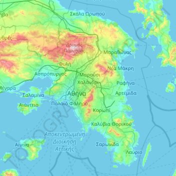
Name: Attica topographic map, elevation, terrain.
Location: Attica, Greece (37.64831 23.10669 38.34101 24.08594)
Average elevation: 133 m
Minimum elevation: -1 m
Maximum elevation: 1,384 m
Other topographic maps
Click on a map to view its topography, its elevation and its terrain.
Municipality of Kifisia
Greece > Attica > Regional Unit of North Athens
Municipality of Kifisia, Regional Unit of North Athens, Attica, Greece
Average elevation: 342 m
Ωρωπός
Greece > Attica > Regional Unit of East Attica
Ωρωπός, Municipality of Oropos, Regional Unit of East Attica, Attica, 190 15, Greece
Average elevation: 83 m
Municipality of Oropos
Greece > Attica > Regional Unit of East Attica
Municipality of Oropos, Regional Unit of East Attica, Attica, Greece
Average elevation: 333 m
Kalamos
Greece > Attica > Regional Unit of East Attica
Kalamos, Municipality of Oropos, Regional Unit of East Attica, Attica, 190 17, Greece
Average elevation: 242 m
Athens
Greece > Attica > Regional Unit of Central Athens
Athens, Municipality of Athens, Regional Unit of Central Athens, Attica, 105 57, Greece
Average elevation: 168 m